
34 - 36 Gillygate
Horse fairs, game birds and a narrow escape.
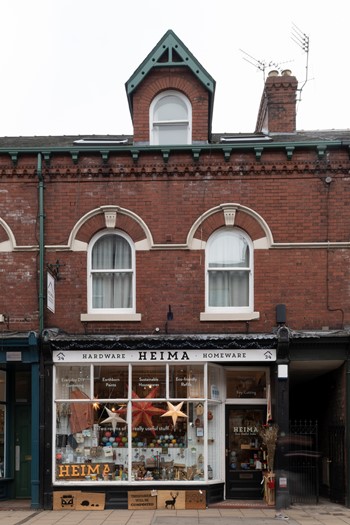
Adjoining the only Grade II* building on the south side of Gillygate you’ll find a group of four late 19th century buildings: nos 30 to 36. Described in the City Council’s Character Area Appraisal as, "buildings of merit”, they make a significant contribution to the historic streetscape and demonstrate a wider variety of styles than those of the 18th century.
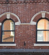
The buildings have bold round-headed windows on the first floor, neoclassical styled - a decorative feature much favoured by the likes of the architect James Demaine (1842-1911) who joined the York practice of JB & W Atkinson in 1870 He was followed by the more famous Walter Brierley in 1885. Each property also has an attractive dormer window in the roof facing the street, decorated with carved bargeboards.
At the rear of no 34 Gillygate there used to be a banana house to ripen the fruit before sending to market, whilst no 36 was said to have removable windows with a large marble slab used for the display of game birds. Some attractive tiles showing ducks in flight adorned the walls (a fond memory for those on the slab).
Pronounced with a soft ‘g’, the name Gillygate hails from the presence of the Church of St Giles, demolished in the 16th century, and the street has had mixed fortunes over the years. An unkempt backwater, it was once one of the streets leading to York’s Horse Fair: a market for horses and cattle dating from medieval times on a site now occupied by York Hospital. At one time the Archbishop of York claimed the right to charge a toll for every animal brought to and leaving the fair - demonstrating a canny ability to double-tax livestock! Gillygate is also the only portion of the city walls where the outer aspect is filled with buildings.
During preparations for the Civil War siege of York in 1644, all the buildings in the moat against the walls were demolished as a defensive measure. This, however, proved futile with York capitulating early in the conflict and opening its main gates to the Parliamentarian forces. As York slowly recovered from the Civil War the area in front of the ramparts on Gillygate was repopulated by a range of buildings, the earliest surviving being nos 26 -28 constructed in 1769 for the master builder Robert Clough.
By the 1930s the idea of removing buildings from moat was again on the agenda, not just for aesthetic reasons but, in the case of Gillygate, to facilitate a wider inner ring road. Our founder, JB Morrell in his visionary book City of our Dreams, 1940, outlined the City Corporation’s thoughts on the matter and Gillygate’s demolition may well have gone ahead had it not been for the massive destruction of property during World War II. Over the next 20 years the City Council saw the benefits of retaining what remained of York’s inner city, along with considering new, more popular ideas for the preservation of York’s unique character.
June Hargreaves in her seminal 1966 York Civic Trust booklet, Historic Buildings - problems of their preservation, argued eloquently on behalf of buildings that might not qualify for Historic England listed status, but contributed to good townscape through their shape, profile, colour, proportion and lively relationship with each other. Her work was to have a profound effect on national legislation and led in part to the creation of what we now term conservation areas. Meanwhile other initiatives came forward to aid the preservation of York and prevent built heritage loss due to lack of funding in the private sector.
Established in 1966, The York Town Scheme, a joint venture between Local Authorities and Government, offered grants of up to 50% to private owners for external works like re-roofing, brickwork, guttering and damp proofing. Originally, Gillygate was not included but by 1980 the City Council realised the merit of adding Gillygate to its area of support. Thus, Gillygate was saved and flourishes. As John Shannon, then Chairman of York Civic Trust said: “The money available inevitably became exhausted, but York Civic Trust recognised the importance of the scheme and made grants to support its continuation.”
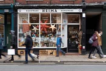
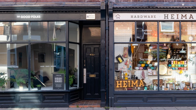
York Conservation Trust also played a part in preserving the character of Gillygate, acquiring no 36 in 1980 and no 34 in 2000. Today, a busy thoroughfare for locals and tourists arriving at Clarence Street car and coach park, no 34 is the much loved local hardware shop Heima, you can read about owner Maff Punton on our tenants page. No 36 is currently occupied by the Good Folks modern-day barbers.
Discover more about 34 - 36 Gillygate
Gillygate
York
YO31 7EQ